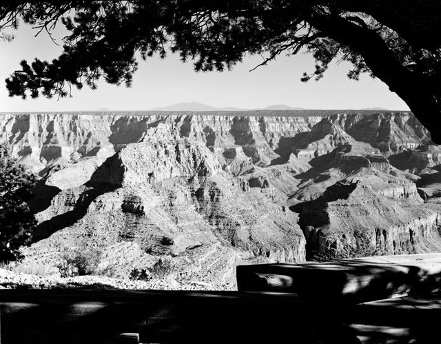
As the southernmost point on the North Rim, Cape Royal provides stunning panoramic views of the Canyon. In this photo from the mid-20th Century, Vishnu Temple is seen in the foreground, while the San Francisco Peaks rise in the distance.
Photo: NAU.PH.2003.11.4.2.B2370. Josef Muench Collection. Cline Library, Northern Arizona University.
Visitors who want to experience one of the most comprehensive panoramic views of the Grand Canyon would be well-advised to stop at Cape Royal on the North Rim. Cape Royal is located on the southernmost tip of the Walhalla Plateau, which juts out like a peninsula into the Grand Canyon, forming the eastern edge of the Canyon’s North Rim. From here, the view stretches from Marble Canyon to the northeast across to the South Rim visitor area at Grand Canyon Village southwest of Cape Royal. Because it encompasses such spectacular vistas, this point was one of the earliest targets of tourism development on the North Rim.
One of the most important early entrepreneurs along the North Rim was Elizabeth Wylie McKee. She and her family operated the main concession in the area from 1917 to 1927. Along with providing food and lodging, they offered tours to Cape Royal and Point Sublime, led by her husband Thomas.
After Grand Canyon became a National Park, administrators of the National Park Service pondered how to develop it to become one of the jewels of the National Park System. In the 1910s and 1920s, NPS leaders envisioned turning parks such as the Grand Canyon into nature resorts by building lodging facilities and pleasurable scenic drives to show off the magnificent natural features of the parks. While parts of the South Rim had already been developed, the North Rim was still virtually a blank slate.
One of the first NPS proposals to develop the area included a plan to build a long scenic drive to Cape Royal and Point Sublime. This grand scheme took a back seat to more pressing construction projects, mostly on the South Rim because the larger number of visitors there demanded it. In the first several years of the park few roads were built or improved; on the North Rim there were no paved roads (except for a 3 mile section built by the Forest Service), only paths that had been worn down by cattle and wagon tours led by entrepreneurs such as “Uncle Dee” Woolley and “Uncle Jim” Owens.
Not until the U.S. Bureau of Entomology began waging a war against insect infestation on the Walhalla Plateau in 1924 did the path to Cape Royal receive any attention, though even then it remained a crude road. Two years later, engineers began surveying a 23-mile scenic road starting at Bright Angel Point and ending in a parking lot at Cape Royal, mostly overlapping the old wagon route and primitive roads constructed in previous years. The road took nearly four years to complete at a cost of over half a million dollars, a lot of money in 1924, and connected to the North Entrance Road, making Cape Royal one of the more easily accessible points for visitors to the North Rim. Later, the construction camp that had housed workers on the Cape Royal Road would become a Civilian Conservation Corps camp.
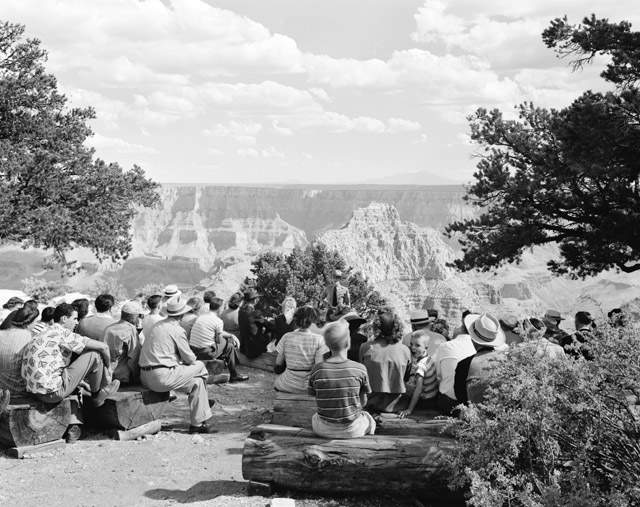
The National Park Service was eager to institute visitor services at Cape Royal, but budgets and other restraints kept them from developing a large cluster of buildings there. Instead, they relied upon ranger talks (such as the one pictured here) and ranger-led hikes at Cape Royal to help introduce visitors to the geology and history of the North Rim of the Grand Canyon.
Photo: NAU.PH.2003.11.4.2.B2391. Josef Muench Collection. Cline Library, Northern Arizona University.
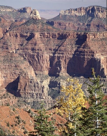
Visitors driving to Cape Royal can enjoy the forests and meadows of the Walhalla Plateau. In autumn, the golden leaves of aspen trees provide a shimmering contrast to the rusty red and white cliffs and buttes of the Grand Canyon.
Photo: NAU.PH.2003.11.4.2.M4626. Josef Muench Collection. Cline Library, Northern Arizona University.
To further attract motorists on tight budgets, the NPS developed a primitive campground at Cape Royal in 1931. At this time and into the 1940s, Union Pacific Railroad’s subsidiary Utah Parks Company ran newly developed concessionaire facilities on the North Rim and offered guided auto sightseeing trips to Cape Royal.
Though the Company would have liked more development at Cape Royal and other sites, the Great Depression, combined with the NPS desire to cultivate a sense of pristine wilderness, restricted building schemes in this period. The Company had envisioned building visitor facilities at Cape Royal similar to Grand Canyon Lodge that would include standard and deluxe cabins, but like most other business plans hatched in 1929, it went the way of the stock market.
Though pressure and plans to build more facilities at Cape Royal continued to arise over the next several decades, it was never significantly developed. For example, as part of the wave of building that took place during the Mission 66 program, administrators proposed building a facility similar to Yavapai Observation Station at Cape Royal to serve the interpretation needs of North Rim visitors. In the end, most of the Mission 66 development at the Grand Canyon took place on the South Rim, and NPS interpretive facilities at the North Rim remained confined to a small room within Grand Canyon Lodge.
From 1959-1963 workers reconstructed Cape Royal Road, taking care to maintain its original alignment to avoid further environmental damage. Crews improved grading and drainage features, widened the surface, and expanded scenic pullouts and parking areas along the road. Today the scenic 23-mile road from Grand Canyon Lodge to Cape Royal passes through a forest of spruce, ponderosa pine, and aspen on the Walhalla Plateau, as well as fields filled with colorful wildflowers, deer, and Kaibab squirrels. An excerpt from poet May Swanson’s “The North Rim” conveys her impressions of Cape Royal:
Two coils of the river seen from here,
muddy infinite oozing heavy pain.
Each object has its shadow. Or, if not,
must vanish. Now while the sun leans,
tabernacles form. Allow dark openings,
violet-cool arcades. Establish bases,
though colosseums, carved by the shift
of a cloud, descend pendant,
and Great sinks into shadow.
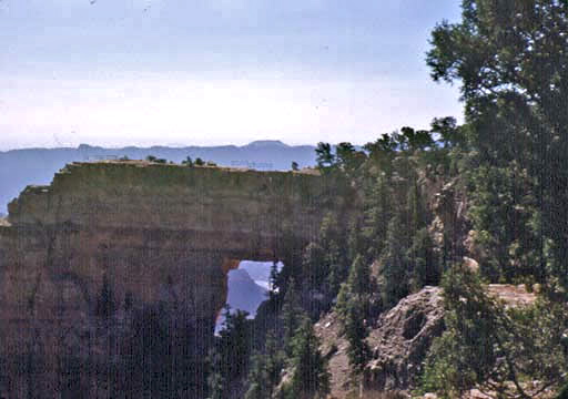
The Colorado River is visible through Angel’s Window as seen from Cape Royal on the North Rim. Visitors can take a short path that travels across the top of the arch to a viewpoint at the tip.
Photo: NAU.PH.97.9.416. Gladys Virginia Broderson Collection. Cline Library, Northern Arizona University
An easy round-trip trail at Cape Royal leads hikers on an approximately 1-mile long paved walk with interpretive signs that explain the natural history of the area and provide views of the Unkar Delta and the Colorado River. The overlook at the end of the trail provides good views of Wotan’s Throne and Vishnu Temple. Desert View Watchtower, Grandview Point, and Horseshoe Mesa on the South Rim are also visible from this point.
One of the most well-known features visible near Cape Royal is Angel’s Window, a large natural arch that eroded out of one of the rock formations jutting into the canyon. It can be viewed by taking a half-mile spur from the main trail. For more adventurous hikers, this spur continues on across the arch to a viewpoint on the tip of the outcropping.
Written By Sarah Bohl Gerke
References:
- Anderson, Michael. Polishing the Jewel: An Administrative History of Grand Canyon National Park. Grand Canyon Association, 2000.
- Krutch, Joseph Wood. The Grand Canyon: Today and All Its Yesterdays. Tucson: University of Arizona Press, 1989.
- Swenson, May. Nature: Poems Old and New. New York: Mariner Books, 2000.