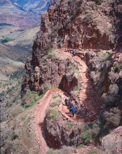
Hikers descend steep switchbacks through the Redwall Limestone on the Bright Angel Trail above Indian Gardens.
Photo: Mike Quinn, NPS photo
Most visitors who decide to venture below the rim of the Grand Canyon will probably find themselves walking along the Bright Angel Trail, which begins just west of Bright Angel Lodge near Kolb Studio in the Grand Canyon Village. However, few are likely to know of the long and bitter battles fought over who would control the trail, battles pitting small businessmen against large corporations, and private rights versus public interests.
As one of the major fault lines bisecting the Canyon, the Bright Angel Fault has for centuries allowed animals and humans access into and out of the Canyon. Some of the earliest Euro-American visitors were well aware of the important role nature played in shaping human history at the Canyon. For example, George Wharton James [link to literature page] stated at the turn of the 20th Century, “Imagine what the descent of this great gorge would have been had not the processes of nature kindly broken up these precipitous walls into sloping taluses upon which the trails of pygmy man could be cut” (James 1900: 132).
Among the first humans to use what is now known as Bright Angel Trail were ancient hunter-gatherers who likely followed animal paths into the Canyon and then over time improved their own trails. Today evidence of their use of this path can be found in the many pictographs dotting the Canyon walls along the trail depicting successful hunts and giving future visitors directions.
Havasupai, and probably other tribes who came to visit or trade with them, later wore down a more definite path along this route in their travels between the South Rim and Indian Garden, about a five mile trek below the rim. This was a valuable site to the Havasupai because of the perennial waters of what is now called Garden Creek, which they used to water the fields of crops they maintained there, and because of nearby sheltering caves.
In the late 1880s, Euro American prospecting partners Pete Berry and Niles and Ralph Cameron improved the trail at a cost of $500 in order to better reach mining sites within the Canyon. In February of 1891, Berry registered it with Yavapai County as the “Bright Angel Toll Road,” though it was often known also as “Cameron’s Trail” because Berry transferred control of the trail to Ralph Cameron in exchange for ownership of the Grand View Toll Road (today’s Grandview Trail). Cameron saw the money to be made from tourists rather than mining, especially with the advancing Santa Fe Railroad. He made an agreement with the railroad that the tracks they were building to the Canyon would end at the head of Bright Angel Trail near Cameron’s hotel. However, the railroad also made an agreement with Martin Buggeln to continue the tracks all the way to his Bright Angel Hotel, setting up a long series of legal battles between the railroad and Cameron.
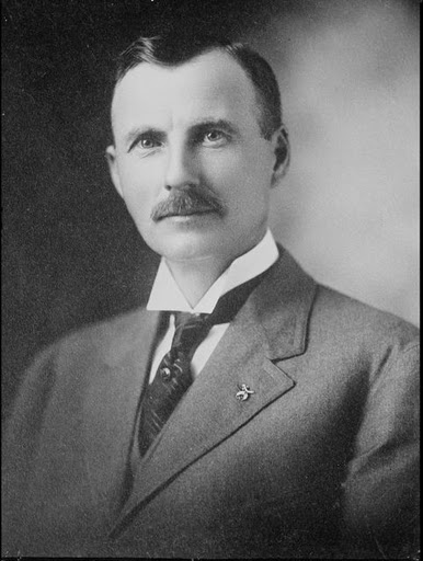
Ralph Cameron used his political influence and the support of local citizens to maintain control over the Bright Angel Trail for nearly three decades.
Photo: Library of Congress Prints and Photographs Division, George Grantham Bain Collection. LC-B2-5423-1
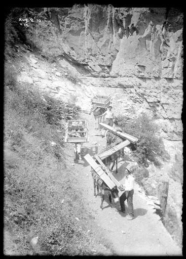
When constructing the trail and any facilities along it, all materials had to be carried into the Canyon by muscle power or by pack mule. In this photo, mules haul lumber for the Kolb Brother’s auxiliary photography studio at Indian Garden.
Photo: Northern Arizona University Cline Library, Emery Kolb Collection, NAU.PH.568.7226
Cameron invested several thousand dollars into developing the trail, extending it so that it eventually reached all the way from the South Rim to the Colorado River. He also established a camping area at Indian Garden, though he did not keep it in good repair. To recoup his costs (and make a tidy profit), in 1903 he began to charge everyone who wanted to use it $1, plus additional fees for drinking water and other services. Cameron made an arrangement with the Kolb brothers, leasing to them a small plot of land near the trail head so they could set up a photography studio. The brothers began taking photos of visitors on mule rides down Bright Angel Trail, making a lucrative business selling them as souvenirs.
In 1906, with his legal claim on the trail running out according to Arizona state statutes, Cameron’s mining and trail-building partner Pete Berry surrendered the road to Coconino County. Cameron, however, was not as willing to let go of the toll road and its profits. As chairman of the Coconino County Board of Supervisors from 1905-1907, Cameron convinced the territorial legislature to pass a law granting toll road developers more control over their investments. This law was written in such a way that it primarily benefitted Cameron, and though the governor vetoed the bill, territorial residents favored private enterprise and garnered enough votes to override the veto. Cameron, as head of the board, awarded himself control of the road for at least the next five years, despite a lucrative offer to purchase it from the Santa Fe Railroad.
During this time Cameron continued to improve his trail, constructing two tunnels along its upper segment to make it more easily traversable. When his contract finally ran out in 1912, ownership of the trail transferred to Coconino County. However, Cameron continued to exert a strong political influence over the county and what they did with the trail. The county continued to charge visitors one dollar per person to utilize it.
Cameron served as territorial representative to Congress beginning in 1908 and later as U.S. Senator from 1921-1927, and his connection to men of influence helped his home county maintain their grasp on the trail, which eventually became the last remaining toll trail within the National Park system. The National Park Service attempted many times to purchase the trail or force Cameron and the county to relinquish control, but these efforts were cannily rebuffed. Many locals enthusiastically supported Cameron and his tenacious efforts to maintain the county’s hold on the Bright Angel trail in the face of threats from the Santa Fe Railway and the NPS, viewing it as emblematic of the little man fighting large corporations and federal interference in local matters.
Ralph Cameron agreed to let the Kolb Brothers establish a photography business near the Bright Angel Trailhead. For many years the Kolbs ran a lucrative business taking photographs of tourists traveling down the trail, which they often purchased to take home as souvenirs.
Photo: Northern Arizona University Cline Library, Emery Kolb Collection, NAU.PH.568.1259
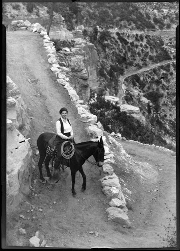
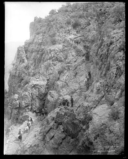
Even though Cameron spent a great deal of time and money improving his trail, it was still narrow and fairly treacherous in some places.
Photo: NPS
Seeing that they could neither bully nor buy out Cameron or Coconino County, the Santa Fe Railroad and the Park Service developed their own trails into the Canyon. The Santa Fe developed the Hermit Trail in 1910 to take visitors to their facilities in the interior of the Canyon at Hermit Camp, while the frustrated NPS constructed the South Kaibab Trail to provide free rim-to-river access and an alternative route to Phantom Ranch.
Finally, after a long series of legal battles and with Cameron’s political influence waning, Coconino County in 1928 agreed to cede control of the trail to the National Park Service in exchange for a new approach road to the park. The NPS debated briefly over whether to close the trail, since they had just built the South Kaibab Trail and were concerned over the costs of maintaining two trails to the same place, but soon decided it was useful to have two paths to the river as well as access to Indian Garden. However, they did promptly eliminate the toll.
Over the next 11 years the NPS, using mostly Civilian Conservation Corps and Havasupai workers, reconstructed nearly the entire length of the trail to make a more uniform gradient and widen the trail to the standard width of four feet. In many places the historical route was altered, which sometimes meant carving the trail out of solid rock, until in 1939 the trail was completed in the form modern visitors traverse today. The CCC also constructed trail shelters called Mile-and-a-Half House, Three-Mile House, Indian Garden Rest House, and River Rest House, which have provided many hikers with greatly appreciated shade and facilities.
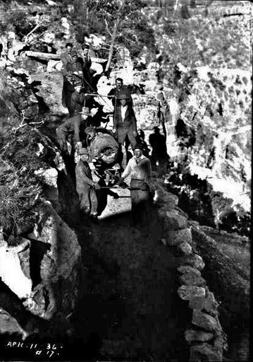
Some things needed in the Canyon mules simply could not carry, such as this piece of trail-building machinery used in reconstructing the trail in 1936.
Photo: Northern Arizona University Cline Library, Emery Kolb Collection, NAU.PH.568.1876.
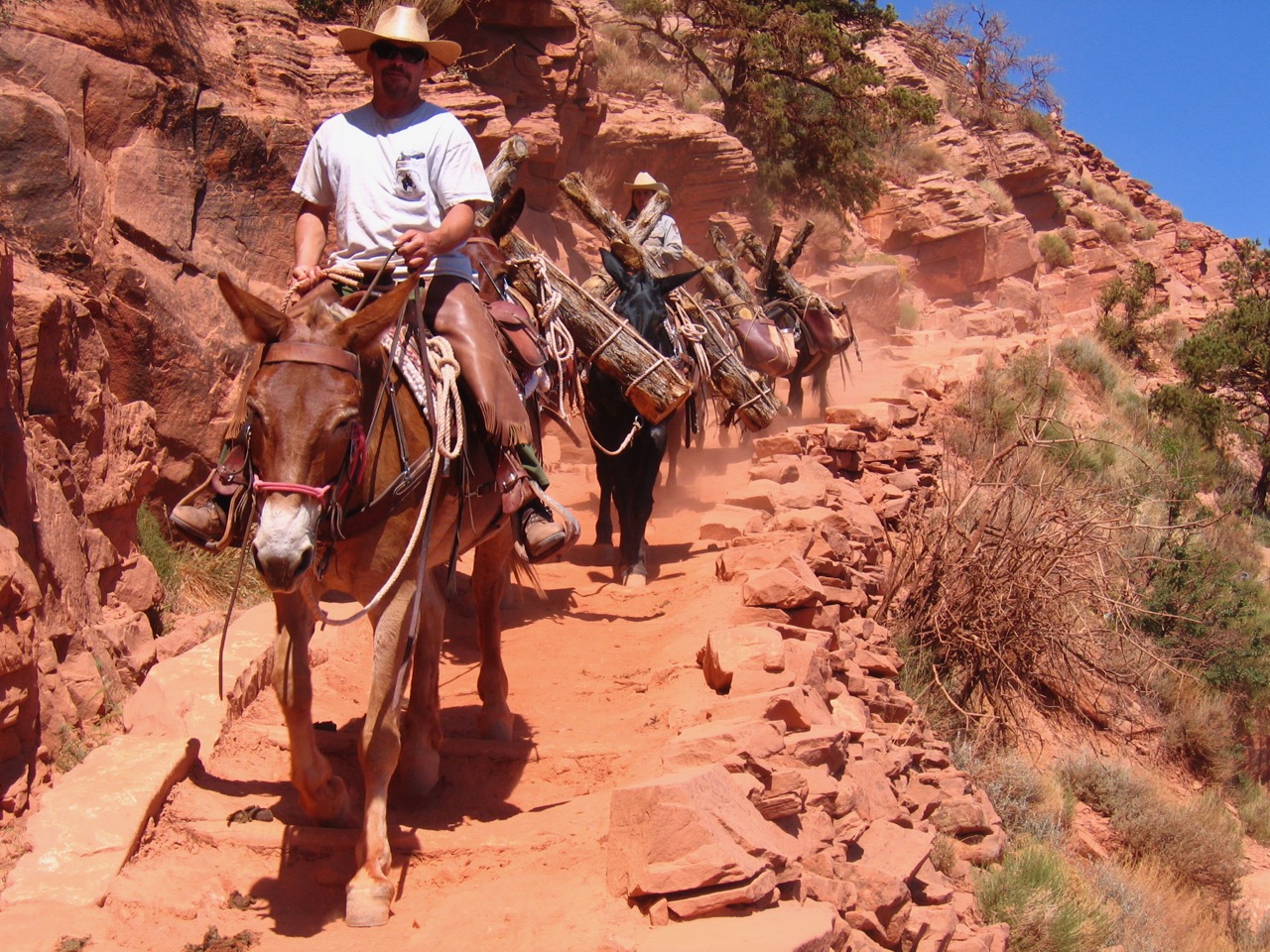
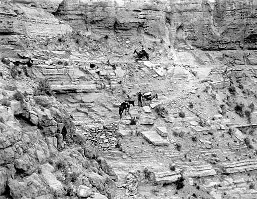
A mule party heads turns through one of the switchbacks along Bright Angel Trail.
Photo: Northern Arizona University Cline Library, Josef Muench Collection, NAU.PH.2003.11.4.1.5.B-1894.
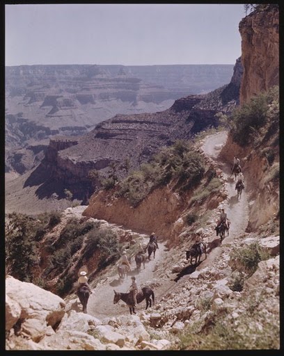
One common feature of the Bright Angel Trail that hikers will rarely encounter elsewhere is the presence of mule trains . Early miners and other Euro Americans living at the Canyon would make extra money by leading tourists into the Canyon on mules or horses. Today, the Grand Canyon National Park Lodges coordinate these mule rides, all of which use the Bright Angel Trail as their main thoroughfare. Though these mule trains still depart from the Canyon every day, and are fully booked months in advance, by 1946, the number of hikers along the trail equaled or surpassed the number of mule riders, putting such pressure on the trail that rangers sometimes diverted mule trains to the South Kaibab Trail. Today park rangers and mule wranglers have worked out a better system by which to share the trail, and often hikers will be called upon to step to the side so the highly-trained mules can continue down narrow sections of the trail.
Apart from the mules, wildlife makes its presence known to visitors along the Bright Angel Trail who listen carefully. George Wharton James described in 1910 that “One will generally hear the sweet descending ‘pipe’ of the canyon wren, and the harsh scolding of the blue-winged pinion jay. Hawks, owls, mocking-birds and robins are often seen. Butterflies, moths, and humming-birds wing their way to and fro and give a delicate touch of life to the stern rocky features. Time was when the visitor at El Tovar who went down the trail to the river might have seen mountain sheep, bear, deer, antelopes and coyotes” (James 1910: 60).
The trail also provides an up-close lesson in geology and archeology. The top of the trail is wide with gentle switchbacks. Near the first tunnel of the trail, ancient pictographs are visible. As hikers continue down the trail, the cut of the Bright Angel Fault, which made the landscape amenable to trail building in the first place, is very obvious. For example, at the contact between the Supai and Coconino formations, near the second tunnel along the trail, the formations are nearly 200 feet higher on the west side than on the east. More pictographs are visible near Two Mile Corner. Another mile down the trail, near the three-mile resthouse, are the remains of the old cable car system that miners and the NPS used to bring supplies down to Indian Garden. Beyond this resthouse, the trail becomes steeper as it descends through the Redwall limestone and Muav formation. A series of switchbacks known as Jacob’s Ladder, in which steps were cut out of solid rock, provides some challenge before the trail levels out and takes hikers along Bright Angel Shale, which forms the Tonto Platform all along the Canyon, to Indian Garden where archeological remains are widespread.
Past the garden, the trail gradually descends to the Tapeats Sandstone formations and into the Devil’s Corkscrew, a series of tight, steep switchbacks cutting down 1200 feet through Vishnu Schist. The Colorado River is another half mile beyond this point, technically marking the end of the trail, though many hikers consider the two-mile River Trail that leads to Bright Angel Campground and Phantom Ranch to be part of the Bright Angel Trail.
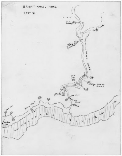
Map of the Bright Angel Trail from 1972 including USGS benchmarks, locations of rest areas, and other spots of interest.
Photo: Northern Arizona University Cline Library, Bradford Washburn Collection, nm320g00s002b001f0017i001p001.
Sure-footed mules pick their way carefully through Jacob’s Ladder along the Bright Angel Trail.
Photo: Northern Arizona University Cline Library, Emery Kolb Collection, NAU.PH.568.8793.
The trail descends a total of 4380 feet, with an average grade of 10% along its entire length. The NPS has categorized this as a corridor trail, meaning it receives regular maintenance and is patrolled by park rangers. However, even though the well-maintained trail has more shade than other Grand Canyon paths, hikers should be cautious and come well-prepared if they plan to travel a significant distance along the trail, since it can still be incredibly hot and there are few water sources. If done correctly, as George Wharton James said in 1900, “It is…a fascinating but rather arduous trip which every visitor should take, for, when the weariness is forgotten, a delightful and never exhausted memory is the reward” (James 1900: 138).
Written By Sarah Bohl Gerke
Sources:
- Anderson, Michael. Polishing the Jewel: An Administrative History of Grand Canyon National Park. Grand Canyon Association, 2000.
- Anderson, Michael, Mark Jacobson, Debra Sutphen, and Amanda Zeman. Bright Angel Trail National Register Nomination, 2006.
- James, George Wharton. In and Around the Grand Canyon. Boston: Little, Brown, and Company, 1900.
- James, George Wharton. The Grand Canyon of Arizona: How to See It. Boston: Little, Brown, and Company, 1910.