The Navajo Reservation, the largest in the country, sprawls across the upper northeast corner of Arizona and into parts of New Mexico and Utah. At 27,000 square miles, it is approximately the size of the state of West Virginia; in fact, it is larger than 10 states. Today the tribe has a population of about 290,000, making it the largest Native American nation in North America, with nearly 75% of Navajos living on the reservation. The Colorado River forms 76 miles of the Reservation’s western border, which stretches from the mouth of the Little Colorado River to the Glen Canyon Dam. The Reservation is located on the Colorado Plateau and contains a great deal of ecological diversity. The land is full of deserts, grasslands, forests, mountains, plateaus, mesas, and canyons that include a wide range of elevations and climates.
Though Navajo stories tie them to the lands of the Colorado Plateau from time immemorial, archeologists believe they were relative newcomers to the Southwest, arriving sometime between 1000 and 1500 A.D. The Navajos were primarily hunter-gatherers, but began changing into a more sedentary life after they learned agricultural techniques from their Puebloan neighbors. The Puebloans also influenced Navajo religion, arts and crafts, and social conventions. Around the beginning of the 18th century, the Navajos once again adapted themselves to become avid livestock herders with the influx of Spanish domesticated animals. They also gained a reputation as fearsome and aggressive raiders.

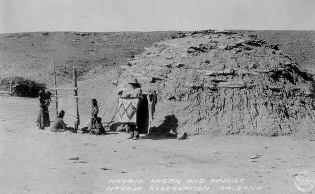
Three Navajos eat breakfast outside a temporary hogan on the Navajo Reservation around 1903. Hogans can still be seen today around the reservation, though most Navajo live in modern housing, some of which is shaped like a hogan.
Credit: Library of Congress, Prints and Photographic Division, LC-USZ62-56414

Though the Navajos are famous as shepherds, they are also agriculturalists. The poor soil and arid climate required them to develop special farming techniques, as seen in this corn field.
Credit: Western History/Genealogy Division, Denver Public Library
In 1863 the U.S. Army sent Col. Kit Carson into Navajo land to force the Navajos away from their homeland to Bosque Redondo on the Pecos River in New Mexico. There they lived under Army guard at Fort Sumner. Many sought refuge in Canyon de Chelly, but in the end the Army’s destruction of their crops and livestock and the constant war waged against them forced the tribe into surrender. They were force-marched hundreds of miles in the “Long Walk.” By the end of 1864, about 75% of the tribe had arrived at Bosque Redondo, with the rest fleeing westward and living in small groups or among friendly neighbors. Although a miserable experience for the Navajos, their time at Bosque Redondo helped to solidify their tribal unity and ended their history of raiding.
Four years later, the Navajos and the American government signed the Treaty of 1868, which granted the people a reservation and released them from Bosque Redondo, allowing them to return to their homelands to the west. Over the next several years, the Navajos managed to add to their land base even as other Native American tribes were steadily losing theirs. The Navajo population grew rapidly, and much of the land they gained came from what had been Hopi reservation land. As the Navajos quadrupled the size of their reservation through a series of executive orders and Congressional acts, they heightened conflicts with the Hopis. By 1934 the Navajo Nation encircled the Hopi reservation. This expansion brought the Navajo into an long-running conflict with the Hopi (read more about the Navajo-Hopi land dispute below).
Oil was discovered on the Navajo Reservation in the early 1920s. The Navajo Tribal Council was established in 1923, primarily to deal with oil and mineral companies that wanted to lease Navajo land, but also to administer timber resources and develop a water supply for their livestock. The reservation was so large that this council was not effective at first, and in 1927 it divided into smaller local chapters that reported to the council. In 1969, the tribal council passed a resolution officially establishing the Navajo Nation.
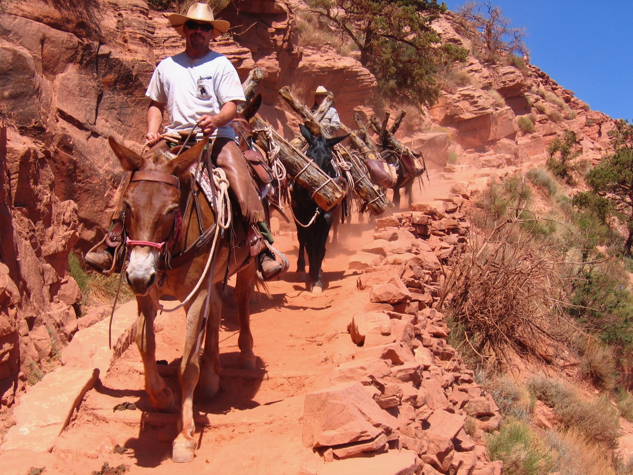
When Kit Carson came to remove the Navajo to Bosque Redondo in the mid 1860s, many sought refuge in Canyon de Chelly. Though some were able to escape and live in hiding for the next several years, most were captured and forced to leave their homelands. Four hard years later they returned, and today continue to inhabit the canyon.
Credit: Sarah Bohl Gerke
A Navajo woman sits in front of a loom surrounded by her children, as her husband displays a blanket she has completed in front of their large hogan.
Credit: Western History/Genealogy Division, Denver Public Library
In the 1930s, the federal government forced the Navajo to reduce their livestock because of concerns about overgrazing and erosion. This caused a massive disruption in the Navajo economy and angered many tribal members. Deep resentment still lingers today.
After World War II, companies became even more interested in the large oil and gas fields on the reservation, and revenues from their leases were reinvested in the reservation. In the 1960s coal, helium, and uranium mining companies set up operations on the reservation, further enriching the tribe, but also bringing environmental problems such as air pollution, radiation poisoning, and depletion of the groundwater table. Many Navajos are also angry that most revenue from resource development on the reservation goes to U.S. corporations instead of Navajo companies and communities.
The US government also threatened the environment of the Navajo Reservation. As early as the 1940s, the Bureau of Reclamation put forth proposals to build a dam at Marble Canyon on the western boundary of the Navajo Reservation. Though it would have flooded reservation lands, the Navajo were not brought into discussions about the proposals. Activists protested this dam, and in 1969 President Lyndon Johnson created Marble Canyon National Monument to protect the area. This monument was later absorbed into Grand Canyon National Park by Congress’s 1975 Grand Canyon National Park Enlargement Act.
However, this act led to new tensions between the National Park Service and the Navajo. The NPS argues that the boundary of the reservation is along the South Rim (despite a 1979 Colorado River Management Plan which allows Navajos to continue to use and occupy lands below the rim), while the Navajos argue that it reaches all the way to the Colorado River. The Navajos are interested in developing canyon-related tourism, but often the tribe and the NPS do not see eye-to-eye on the “appropriate” use of these lands.

The Navajos have long raised sheep to provide them with wool to weave blankets and for meat. Despite a forced stock reduction in the 1930s that caused a great deal of controversy, the Navajos maintain their identity as sheep ranchers into the present day.
Credit: NAU Cline Library, Josef Muench collection, NAU.PH.2003.11.3.E1666
Navajo men gather, some traveling considerable distances, for a ceremonial sing, a social and religious event that helps reaffirm tribal history and identity.
Credit: NAU Cline Library, Josef Muench collection, NAU.PH.2003.11.10.2.6920
Tourism has become an important part of the Navajo economy and is continuing to expand. Visitors can attend a number of cultural events on the reservation, such as song and dance contests and intertribal powwows. The reservation contains many sites for historic, archeological, and environmental enthusiasts, such as Canyon de Chelly National Monument, Hubbell Trading Post, and Monument Valley. In fact, Monument Valley, which provided the scenic backdrop for many historic western movies, has been run as a tribal park since 1960. Many Navajos operate tour companies to serve visitors to their reservation who come from all over the world.
The Navajo world view values continuous growth and renewal, and it is this spirit that has helped their nation survive and thrive over many centuries and provides hope for a bright future.

Scenic Monument Valley, made famous by movie westerns, is located on the Navajo Reservation and is operated as a tribal park.
Credit: Moritz Zimmermann, Wikimedia Commons
The Navajo-Hopi Land Dispute
One of the most contentious issues among both the Navajos and Hopis has to do with reservation borders and land use. Disputes between the Hopis and Navajos over reservation lands have been going on for decades and continues into the present day. Both tribes are deeply tied to the land, and both have compelling claims to the disputed area.
This dispute stretches back to the creation of the Hopi reservation by President Chester A. Arthur in 1882. The president issued an executive order granting 2.4 million acres “for the use and occupancy of the Moqui (Hopi) and other such Indians as the Secretary of the Interior may see fit to settle thereon.” This vague wording is the basis for the land dispute. There were around 300 Navajos (and Paiutes) living in the area who believed they were the “other such Indians” who were entitled to stay, especially since the Hopi towns were located on their mesas and the Hopis did not use all of the reservation for settlement, only for religious ceremonies. The Hopis argue that the presidential order did not specifically mention the Navajos, and that its intent therefore was to grant the Hopis primary control.
The hostility between the Navajos and Hopis over this land led the Secretary of the Interior in 1891 to designate 300,000 acres of the 2.4 million granted in the 1882 act exclusively to the Hopis. This exclusive Hopi reservation was more than doubled in size in 1943, forcing around 100 Navajo families living in this area to relocate. Still, by 1960 there were about 8,500 Navajo living on land within the 1882 Hopi Reservation boundaries.
The matter was further complicated by a 1934 bill to establish new Navajo Reservation boundaries and eliminate private landholdings within them. This granted about 1 million acres in Arizona to the Navajos. However, it also stated that the lands were set aside for the Navajos and “such other Indians as are already settled thereon,” which included the Hopi village of Moencopi.
In 1962, the Hopi Council sued the Navajo Tribe in Arizona District Court to reinforce the Hopis’ claim on the land allocated exclusively to them in 1943. The court found that each side had valid claims, which did little to appease either side. In 1970 the U.S. government decreed some lands fought over by the Hopis and Navajos as a Joint Use Area. Five years later, a Congressional Act divided the Joint Use Area into exclusive Hopi and Navajo areas, though the tribes must still equally share all subsurface mineral rights.
During the 1960s and 70s, negotiating committees from both tribes met several times to try to resolve their differences, with no success. Finally in 1974 Congress passed the Navajo-Hopi Bill into law. It paid the costs of relocating Navajos currently living on exclusive Hopi lands, and authorized the Secretary of the Interior to sell them BLM land on which to resettle. All non-Hopis living in the exclusive Hopi area were supposed to move by 1986 and vice versa.
Many Navajos eventually moved, but some refused, and as the removal deadline approached, they appealed to Congress for help. In 1980 Congress passed an act that allowed certain Navajos to stay on the land in life estates, despite protests by the Hopis that their legally established rights were being violated.
By 1999, most of the Navajo families who were supposed to relocate had moved, though several still refused to leave. The Hopis and Navajos finally reached a compromise to allow these Navajos to stay on Hopi land by signing a 75 year lease. In 2000, the Navajos and Hopis agreed to a settlement of $29 million for land use and damages on Hopi land that they claimed was caused by Navajo overgrazing. However, there are still lingering issues and tensions on both sides, and many fear the conflict will never be fully resolved.
For more information on the Navajos, visit their official tribal website at www.navajo.org
Written By Sarah Bohl Gerke
Suggested Reading:
- Anderson, Michael F., ed. A Gathering of Grand Canyon Historians. Grand Canyon Association, 2005
- Bailey, Garrick, and Roberta Bailey. A History of the Navajos: The Reservation Years. Santa Fe: School of American Research Press, 1986.
- Brugge, David. The Navajo-Hopi Land Dispute. Albuquerque: University of New Mexico Press, 1994.
- Goodman, James. The Navajo Atlas: Environments, Resources, People, and History of the Dine Bikeyah. Norman: University of Oklahoma Press, 1982.
- Griffin-Pierce, Trudy. Native Peoples of the Southwest. Albuquerque: University of New Mexico Press, 2000.
- Iverson, Peter. Dine: A History of the Navajos. Albuquerque: University of New Mexico Press, 2002.
- Kammer, Jerry. The Second Long Walk: The Navajo-Hopi Land Dispute. Albuquerque: University of New Mexico Press, 1980.
- Kelley, Klara B. and Harris Francis. Navajo Sacred Places. Bloomington: Indiana University Press, 1994.
- Roberts, Alexa, et al. The River of Neverending Life: Navajo History and Cultural Resources of the Grand Canyon and the Colorado River. Window Rock, AZ: Navajo Nation Historic Preservation Dept, 1995.
- Underhill, Ruth. The Navajos. Norman: University of Oklahoma Press, 1956.
- Weisiger, Marsha. Dreaming of Sheep in Navajo Country. Seattle: University of Washington Press, 2009.
- Yazzie, Ethelou. Navajo History. Many Farms, AZ: Navajo Community College Press, 1971.