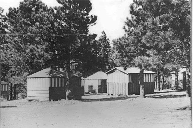
WylieWay Camp, 1917-1927. It was much simpler for the Forest Service and Park Service to lease land through a permit system for tourist concessions. The agency retained control over development and architectural design, could terminate the agreement, and require the private interest to remove all structures after the permit was cancelled.
Photo: Grand Canyon National Park Museum Collection.
How does the moral assessment in the first quote lead to the conditions of the second? Donald Worster, in The Ends of the Earth: Perspectives on Modern Environmental History (Cambridge: Cambridge University Press, 1988), argued that nations and individuals had been moving west from Europe and across what would become the United States since the early sixteenth century, pursuing national empires and personal gain without regard for prior occupants and the natural environment. Aided by generous U.S. land policies and few controls, European Americans occupied nearly all desirable portions of the continental United States within seven generations of the nation’s founding. By the early twentieth century, those pursuing “their own private accumulation of wealth” led to the Forest Ranger’s lament about the private control of land and enterprise in the most visited locations of the new Grand Canyon National Monument.
Despite these strategically located private in-holdings, the vast majority of the Grand Canyon is owned by the federal government, held in trust for the American people and managed by a varied collection of federal agencies. Indian reservations, state land, and private land surround these federal lands.
How did this pattern of land ownership evolve? What are the relationships between these landowners and government agencies? To understand who owns the Grand Canyon and why, we must explore the concept of “public domain,” US land laws, and the mad rush west that the federal government both encouraged and then later restricted.
The term “public domain” refers to land controlled by a sovereign nation. Monarchs ruled most European nations at the discovery of the New World and controlled the land within their boundaries as well as lands they seized on the American continents. They doled out much of it to lords, influential citizens, peasants, and others for various practical and political reasons, but retained a tight grip on ultimate land control. Since the founding of the United States of America in the late eighteenth century, the U.S. public domain has been owned by its citizens, while management policy has been determined by both the Congress and the president, and administered by federal agencies such as the General Land Office (GLO), US Forest Service (USFS), National Park Service (NPS), Bureau of Indian Affairs (BIA), and Bureau of Land Management (BLM).

All early roads from Flagstaff, Williams, and Ash Fork to the South Rim were built by canyon pioneers, who either claimed them as toll roads or considered them proprietary in other ways. None actually charged tolls and all were abandoned or taken over by Coconino County by the 1920s.
Photo: Grand Canyon National Park Museum Collection.

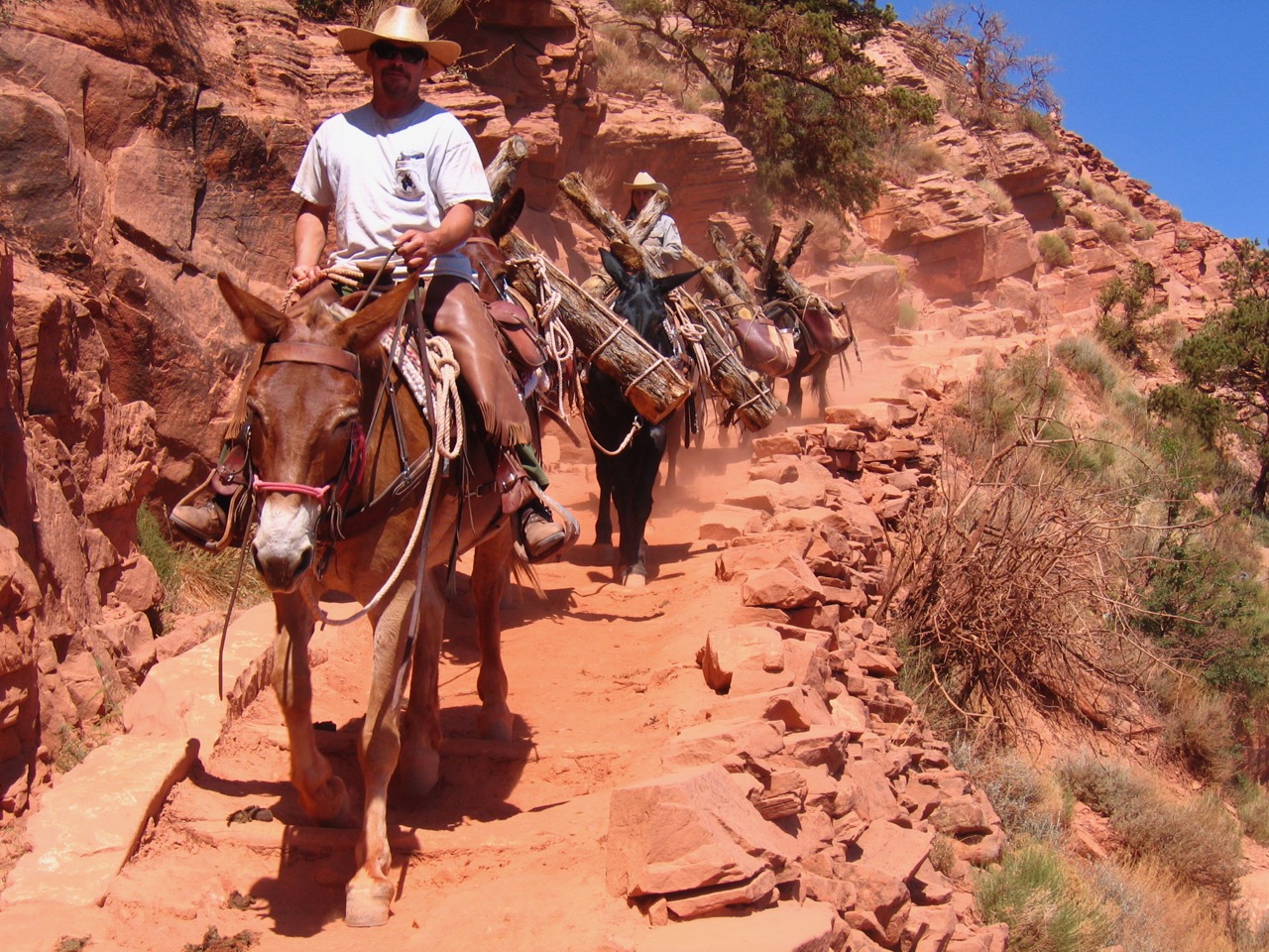
The Horseshoe Mesa breccia pipe contains five contiguous, patented mining claims. Private land in the inner canyon and toll trails leading to them allowed the possibility for unrestrained tourism development, waste dumps, or any other activity chosen by owners. This posed a threat to land managers and encouraged them to reacquire such inholdings.
Photo: Michael F. Anderson.
The United States acquired its first public domain in 1783 with the Treaty of Paris, ending the American Revolution, when Great Britain ceded the American colonies as well as most of its land claims east of the Mississippi River. In the course of the nineteenth century, the young nation acquired the rest of today’s continental United States through a combination of war, annexation, purchase, treaties with American Indians as well as flagrant theft of their lands, and treaties with European nations that had staked claims in the Americas. President Thomas Jefferson bought the continent’s midsection in 1803 from Napoleon Bonaparte and France, a deal known as the Louisiana Purchase.
In 1819 Congress negotiated the Adams-Onís Treaty with Spain, adding Florida to our public domain and requiring Spain to give up claims to the Pacific Northwest. The United States and Great Britain signed the Oregon Treaty in 1846, setting the boundary between the United States and Canada in the Northwest at the 49th Parallel of Latitude. The Treaty of Guadalupe Hidalgo ending the Mexican-American War in 1848 ceded much of Mexico’s Northwest (the U.S. Southwest), including Grand Canyon, to the United States, and the Gadsden Purchase five years later completed today’s boundary with Mexico.
In the end, the US government acquired more than 1.8 billion acres of public domain. Along the way, Congresses and presidents made then abrogated dozens of land treaties with American Indians to create ever-smaller “reservations,” and retained much control over these lands as well, through the Bureau of Indian Affairs.
While our federal government expanded the public domain, pioneering settlers leapt west in a free-for-all manner. The U.S. Land Ordinance of 1785 created the Public Land Survey System, the method still used today wherein the public domain was carved into six-mile-square “townships” of one-mile-square (640-acre) “sections.” The Public Land Survey System accounts for the “checkerboard” appearance on public land maps—each square on the board representing a 640-acre section.
Surveyors had not moved too far west of the original colonies and upper Midwest before Congress created the General Land Office in 1812, responsible for surveying, platting, and disposing of the public lands. The GLO was always a busy agency, trying to keep up with Americans running west as it administered Congress’s various land policies, especially the Homestead Acts beginning in 1862, which allowed settlers to gain title to a quarter section or more of surveyed land. Often, people settled land ahead of the agency’s surveys, “squatting” on unsurveyed land–a practice later legalized under Preemption Acts of the mid-nineteenth century.
After more than a century of concerted land disposal efforts by the federal government, more than two-thirds of the public domain—1.3 billion acres—had been transferred to state and private ownership. The GLO then merged with the U.S. Grazing Service to become the Bureau of Land Management in 1946, charged with managing 264 million acres of remaining public domain land in the arid regions of the West.
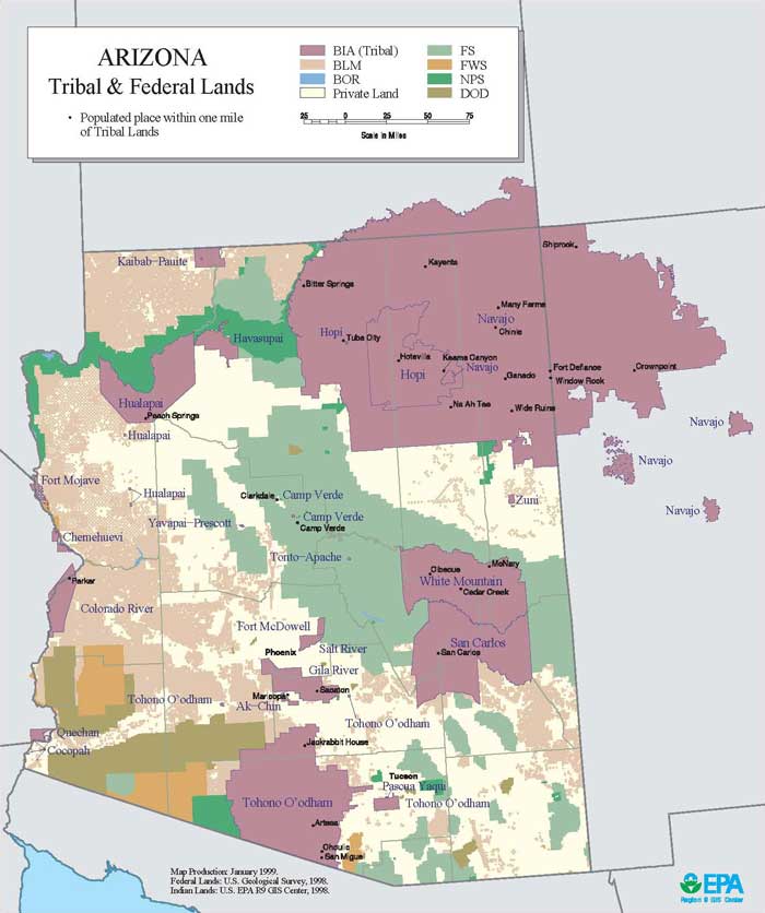
This map by the U.S. Environmental Protection Agency demonstrates the large proportion of non-private land in Arizona. The purple is tribal land; the other colors are federal agencies; the white is private land.
Map courtesy of U.S. Environmental Protection Agency

Bass mining claim in Copper Canyon. William Wallace Bass held a couple dozen valid mining claims, mill sites, toll roads, toll trails, and water cisterns within park boundaries, extending from rim to rim. Given sufficient capital, which he tried but failed to raise, The Bass Trail Corridor could have been developed extensively. At the request of NPS director Stephen Mather, the Santa Fe railway precluded this possibility by buying all of Bass’s interests in 1926.
Photo: Michael F. Anderson.
While the General Land Office went about its methodical surveying and disposal of the public domain, Congresses and presidents often made less methodical land assignments to first develop and then later conserve public lands. Mining laws of the late 1860s and early 1870s allowed anyone to file claims to public lands containing valuable minerals.
Generous land grants were ceded to canal builders and transcontinental railroad companies to help fund construction of transportation systems. Railroads also received rights-of-way and depot grounds to support their operations. Congress gave land to states and gave both states and territories the right to give away or lease land for a variety of purposes, including roads, prisons, government buildings, military reservations, irrigation, and education.
In 1891, two years before historian Frederick Jackson Turner announced the “end of the frontier,” Congress began to slow the private acquisition and wasteful destruction of public lands when it passed the Forest Reserve Act, which gave presidents the authority to establish forest reserves on portions of the public domain lands.
By the time Grand Canyon had garnered the nation’s interest in the late nineteenth century, all of the aforementioned laws, policies, and individual proclivities had left their mark. President Benjamin Harrison designated the Grand Canyon Forest Reserve in 1893.
Congress finally created the U.S. Forest Service in 1905 and renamed the forest reserves “national forests” in 1907. The Forest Service promoted responsible, sustainable development of timber, water, livestock grazing, and other economic activities, but limited staff and pressure from businesses and politicians made it difficult to control development on the national forests.
President Theodore Roosevelt was an avid big game hunter and an advocate for preserving America’s wild game and fish. He proclaimed Grand Canyon Game Preserve in 1906, intending to protect the canyon’s deer, but these efforts launched an unwise war against predators and did not end private land acquisition in the preserve. Only in 1908, when Roosevelt used the 1906 Antiquities Act to create Grand Canyon National Monument, did the opportunity for “private entry” (individual land claims) end. Measures to protect Grand Canyon for future generations took a lengthy and crooked course, allowing alert individuals plenty of time to establish private land claims before 1908.
Since Roosevelt’s proclamation protected valid existing land claims within the monument, landowners remained a challenge to federal administrators. The U.S. Forest Service managed Grand Canyon Forest Reserve and Grand Canyon National Monument from 1905 through 1919. Forest rangers tried to instill order into the booming tourism business at Grand Canyon’s South Rim, but their agency’s mission under Chief Forester Gifford Pinchot was to promote sustainable timber harvesting, not to control and accommodate tourists. Congress appropriated very little money for recreation management, and rangers had no experience toward this end, so the Forest Service formed an informal partnership with the Atchison, Topeka & Santa Fe Railway and Fred Harvey Company to handle tourism while enlisting the aid of the General Land Office to go after the men who had exploited federal mining laws to tie up roads, trails, and other parcels of desirable land. Rangers assayed hundreds of mining claims and informed the GLO of those that contained no commercial grade ore. The land office in turn invalidated these claims and returned them to the public domain. But it was a lengthy process, sometimes disputed in court, and the Forest Service could not finish the job before Congress created Grand Canyon National Park in 1919 and turned management over to the three-year-old National Park Service.
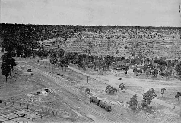
Western portion of Grand Canyon Village ca. 1905.
Ralph Cameron controlled the western portion of the early Grand Canyon village through bogus mining claims. This allowed him to run a private hotel (pictured) while the larger landscape remained a wasteland with open wastewater ponds, pit toilets, and other unseemly structures inappropriate for a national park.
Photo: Grand Canyon National Park Museum Collection.

Bright Angel tollgate.
The Bright Angel toll trail was the only canyon trail operated as a toll road, first by Ralph Cameron, 1903-1912, then Coconino County, 1912-1928. The Forest Service and Park Service considered such tolls unfair to tourists and incompatible with a national monument and national park, but they were legal under territorial and state laws.
Photo: Grand Canyon National Park Museum Collection.
In creating Grand Canyon National Park, Congress protected valid existing private land “inholdings” as had Roosevelt when creating the monument. But the Park Service had, and still has, a different mission—“to conserve the scenery and the natural and historic objects and the wild life therein and to provide for the enjoyment of the same in such manner … as will leave them unimpaired for the enjoyment of future generations.”
The new agency also was given more money to fulfill its mission. Mining claims posed the greatest threat to park resources and public use. Other land claims were considered lesser threats: The Grand Canyon Railway’s 400-foot right-of-way and 20-acre depot site in the middle of the emerging Grand Canyon Village, tens of thousands of acres of state lands, several sections of old Atlantic & Pacific transcontinental railroad land grants, a few 160-acre homesteads, and a dozen or so toll roads and trails would be addressed in later years as attention and money allowed.
Early National Park Service administrators immediately went after men who still held illegitimate mining claims within the park; particularly, an early prospector, miner, tourism operator, and politician named Ralph Cameron. The General Land Office had voided hundreds of Cameron’s bogus claims as early as 1909, but Cameron retained possession through litigation, influential political friends, and his own political power into the early 1920s.
In 1920 the Park Service engaged the U.S. Attorney General to evict Cameron’s workers from Indian Garden and settle the matter once and for all, but Cameron was elected to the United States Senate in the same year and used his political position to linger a few more years. By 1924, however, federal authorities had ejected his workers and formally returned the last of his illegitimate claims to the public domain where they became part of the national park. The struggle with Ralph Cameron played out in the local and regional news, but dozens of less notorious mining claims were returned to the public domain and national park as late as the 1930s through simple inquiries to the county concerning the validity of the claims.
A great many mining claims within Grand Canyon National Park were valid because they did contain commercial grade ore and had been worked year to year. Park administrators had to respect these claimant’s rights and take different approaches to acquire the land and usage rights. William Wallace Bass, for example, a canyon pioneer since the 1880s, still possessed a couple dozen ore-producing mining claims and associated mill sites and water rights west of Grand Canyon Village in the early 1920s. In 1926 National Park Service Director Stephen Mather convinced the Santa Fe Land Development Company to purchase all of these claims plus Bass’s roads, trails, camps, and water cisterns for $25,000, just to make sure they would never be developed by private concerns. When the Atchison, Topeka & Santa Fe Railway divested itself of tourism operations within the park in 1954, they transferred these properties to the Fred Harvey Company, which in turn donated them to the park in the following year.

Group posing on porch of Cameron’s hotel. William Jennings Bryant is third from left. Kolb brothers photograph, circa 1907. The Cameron Hotel operated in Grand Canyon Village atop a mining claim from 1903 through 1907. Mining law did not limit the number of claims one person could hold, and Cameron tied up a good portion of the South Rim from Hermit’s Rest to Grandview and along several inner-canyon trails from the 1890s through the early 1920s by recording hundreds of mineral-barren claims and holding them through lawsuits and his political influence.
Photo: Grand Canyon National Park Museum Collection.
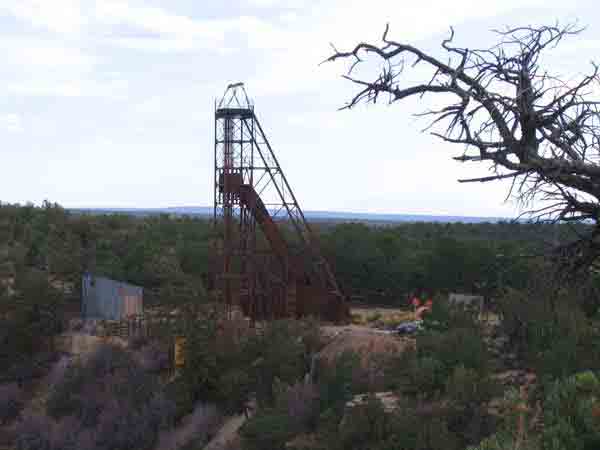
The headframe of Orphan Mine on the South Rim, shown in this 2008 photo, has been dismantled during an environmental site cleanup.
Photo: Patricia Biggs.
Sanford Rowe, an early tourism entrepreneur, had claimed several contiguous parcels a few miles south of Grand Canyon Village in the 1890s, then patented them into private property during the Forest Service era. Succeeding owners continued to operate tourist accommodations on these parcels until the Park Service purchased the land in 1956 and tore down all of the buildings in 1961. The Park Service had a policy of removing unnecessary human disturbances to enhance the “naturalness” of the park, though some people would lament the loss of these historic buildings and businesses.
Other patented mining claims with more complicated histories include the Orphan Mine, just two miles west of Grand Canyon Village on the rim side of Hermit Road, and the Last Chance mine properties thirteen miles east of the village. Dan Hogan and his partner Charlie Babbitt patented the 20.64-acre Orphan lode claim in 1906, and Hogan opened a trading post there in 1936. In 1947 Hogan sold the parcel to Madeleine Jacobs, who leased the tourist facility to subsequent operators but also discovered that Hogan’s copper mine contained some of the highest-grade uranium ore in the American Southwest.
Tourists continued to stay at the camp immediately beside uranium stockpiles until the 1960s. Few people understood the health hazard of uranium ore in those years. Mining ended by 1969, when the government suspended uranium price subsidies, but the land did not return to the public domain until 1987. Only in the early twenty-first century is the park beginning to clean up the radioactive soil and dismantle remaining mining structures.
The Grandview land claims were also favorably situated for Grand Canyon tourism, and their federal reacquisition somewhat more complicated. As early as 1891, prospectors Pete Berry, Ralph Cameron, and several other partners used a combination of federal and territorial land laws to gain control of a copper deposit and a trail they built into the canyon from Grandview Point to access the mine. Pete Berry also claimed and patented a 160-acre homestead near the head of the trail. All of these claims were sold to William Randolph Hearst in 1913. In order to reclaim these properties, the National Park Service employed laws of eminent domain (condemnation) in 1939, igniting a legal battle with the well-known newspaper magnate. Reflecting the lingering power of individual land rights versus federal control, Coconino County newspapers called the Park Service effort a blatant land grab by fascist Nazis, and for good measure, “Russian tactics of the lowest denominator.” Federal judge David Ling called it legal, however, and set the compensation price at $85,000.

The four rim side acres of the 20-acre Orphan lode claim was developed into a tourist facility and uranium mine operation many years after the original copper claim was patented into private land. The park offered its owner, Dan Hogan, only $5,555 for the undeveloped parcel in the 1930s, and has since spent millions reclaiming the radioactive site.
Photo: Grand Canyon National Park Museum Collection.

John Hance’s log cabin/hotel at the Grand Canyon south rim, as well as William Thurber and J. H. Tolfree’s frame services building.
Photo: AHS.0340.00010. Marjorie Flaherty Collection. Cline Library, Northern Arizona University.
Pete Berry’s homestead was one of only two ever patented within Grand Canyon National Park, a fact that is still a historical mystery since anyone could have gained 160 acres of prime real estate along the canyon rim prior to 1908. Perhaps it was the fact that Grand Canyon was not surveyed until after 1902 when Francois Matthes arrived here to survey, in his words, a “hole in the ground” that took several years to complete. In any case, Berry’s homestead was returned to the park in 1939, leaving only the 160-acre homestead of John Hance a few miles southeast of Grandview Point.
John Hance, like many early canyon prospectors and miners, turned to tourism in the early 1880s. He laid claim to his homestead beside the South Rim about the same time as Berry, but did not patent the parcel until 1907 when he sold it to the former manager of the Bright Angel Hotel, Martin Buggeln. Buggeln was not fond of the U.S. Forest Service or National Park Service, and became still more at odds with the latter when they refused to help him launch a tourism business on the homestead in the 1920s. He reciprocated in 1925, by refusing to grant a right of way for the park’s first automotive road, today’s Desert View Drive, causing the park to build along an undesirable alignment a couple years later. Rather than employ eminent domain, park administrators waited until Buggeln’s death in 1939, then obtained an option to buy the homestead from the widow, Eva Moss Buggeln, in 1943. Following the actual purchase in 1948, the Park Service rebuilt the road to Desert View along its more logical modern alignment.
John Hance also made some money from the patent and sale of his asbestos mining claims on the north side of the Colorado River just below the mouth of Red Canyon and Hance Rapid. Hance patented the contiguous claims totaling 325 acres in 1901, then sold them to the Hance Asbestos Mining Company. Park administrators did not even learn of their existence until 1930, but did nothing before the parcel was bought by William Randolph Hearst for back taxes in the 1950s. The land today is owned by the Hearst Estate, the only remaining piece of private land within the original boundaries of the national park. The park revisits the question of obtaining the parcel about every ten years, but since 90 percent of it is along a steep slope and access is limited, administrators appear to be in no hurry.
Privately owned toll roads and trails cut irregular, linear slices through federally owned land at Grand Canyon. People familiar with the early history of Grand Canyon National Monument and Park know about the long, bitter battle over the Bright Angel Trail that raged from 1903 through 1928, but are less familiar with the fact that nearly all early trail and road builders from Flagstaff, Williams, and Ash Fork north to the Colorado River legally filed their travel ways as toll roads and trails.
The Atchison, Topeka & Santa Fe Railway and its subsidiary Grand Canyon Railway “owned” a 20-acre depot parcel and 400-foot-wide right-of-way along the rim near the head of the Bright Angel Trail, which became the heart of Grand Canyon Village. This land was returned to the public domain eighty years later after rail operations to the park ended.
Photo: Grand Canyon National Park Museum Collection.
Since no one controlled the airways above Grand Canyon during the pioneer period, nothing prevented valid land claimants from building tramways on their claims. Roughly a dozen trams operated in Grand Canyon to move equipment, supplies, and ore for brief periods of time, but a permanent tourist tram from rim to rim was proposed in 1919. This was another use of private land that the National Park Service successfully managed to prevent.
Photo: Grand Canyon National Park Museum Collection.
Arizona territorial and state laws allowed such claims, but fortunately did not allow the builders to patent their roads and trails into private land. Rather, they were allowed to charge tolls for a period not exceeding 15 years, after which time all rights reverted to the county government. Once the Grand Canyon Railway reached the South Rim in 1901, only the Bright Angel Toll Road (the trail’s formal name) promised to make money for its builders. All other canyon trail builders allowed their toll claims to expire. Although Ralph Cameron milked the Bright Angel for all it was worth, earning tens of thousands of dollars from 1903 through 1912, its ownership transferred to Coconino County in the latter year. The county continued to charge one dollar per head until 1928, when it traded the trail to the federal government in exchange for an automotive road from Williams to the South Rim (today’s AZ 64).
In retrospect, the National Park Service did a magnificent job eliminating state and private land claims with Grand Canyon National Park, but the public’s use of the park and boundaries drawn between the various land management agencies and American Indian tribes has proven much more complex and controversial. Concerning extractive use, there have never been major disputes between the government and private citizens engaged in farming and lumbering because most of Grand Canyon is not amenable to these enterprises on a commercial scale. Lumber companies operating from Flagstaff and Williams did not approach the South Rim before 1908, after which national monument status precluded these companies from claiming land. In 1919, national park status eliminated even the possibility of Forest Service administered timber sales. The region is too parched for successful dry farming, and would-be farmers simply could not find the water needed for profitable irrigation. The same was true of the North Rim, which did experience limited lumber production by a few, portable Mormon mills, but it was simply too remote for commercial logging until after World War Two. The years 1906 through 1920 were relatively wet on the Arizona Strip and farmers did approach the North Rim near Toroweap, but when drier conditions returned in the 1920s, farm homesteads failed, never to return.
Ranching, on the other hand, did spread onto both rims long before President Harrison’s proclamation of Grand Canyon Forest Reserve and thrived (more or less) into the late twentieth century. Pioneers also grazed a few cattle along the Tonto Platform below the South Rim and many more atop the Esplanade beneath the North Rim. The U.S. Forest Service gained control over these operations after 1897 by instituting a permit system, but did nothing to limit ranchers since the agency’s mission was beneficial economic use of public lands. With its different mission of preservation, the Park Service eliminated all grazing permits within park boundaries by the 1930s. Ranchers’ inholdings and permits played a large part in reducing the boundaries of the new Grand Canyon National Monument designated at Toroweap in 1940, and became an issue again with the Grand Canyon Enlargement Act of 1975, which included lands along the Esplanade that ranchers had long used for livestock grazing. The 1975 act allowed ranchers to continue operations on these lands until 1985, but most gave up their permits long before that year arrived.
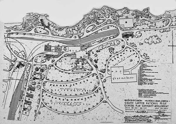
Grand Canyon Village Development Plan, 1924. Since 1905, the Forest Service and Park Service have had to accommodate the existence of a railroad and its rights-of-way within the heart of Grand Canyon Village when planning the orderly development of this gateway community.
Photo: Grand Canyon National Park Museum Collection.

Grandview Hotel built and managed by Pete and Martha Berry. The Grandview area consisted of the most complex set of land ownership and control rights within the park. Pioneers Pete Berry, Ralph Cameron, and a few partners claimed a proprietary access road, a toll trail, patented lode claims and mill sites, and one homestead, all of which restricted tourist access until the federal government condemned all of these claims via eminent domain in 1939.
Photo: Grand Canyon National Park Museum Collection.
European-American settlers had entered Grand Canyon country as early as the 1850s, when the land was controlled but sparsely occupied by American Indian peoples of many different cultures. Nuclear families, extended families, clans, bands, and larger groups used the land in an entirely different manner than white settlers, combining seasonal hunting, gathering, and small-scale agriculture over large areas to survive. Conflict between native residents and the new immigrants ensued, but disagreements played out in a variety of ways. The Hualapais and Navajos chose to fight the U.S. military, while most groups took a path of passive resistance and/or accommodation to European-American ways. The U.S. Congress generally stopped signing treaties with Indian peoples in the 1870s because a treaty acknowledges that both sides in the agreement are nations, while the US government preferred to treat with Indians as dependents. Among the tribes living in or immediately adjacent to the Grand Canyon only the Navajos secured a treaty when their reservation was established in 1868. Reservations in the Southwest thereafter were created through presidential proclamation.
Following their defeat by the U.S. military in the early 1860s, most Navajos (all who could be found) were relocated from their homeland hundreds of miles south and east to a small reservation named the Bosque Redondo at Fort Sumner in New Mexico. Survivors agreed to a treaty in 1868, which allowed them to return to a larger reservation in the four corners area.
Since 1868, the Navajo Reservation has been extended more than a dozen times to about 17 million acres today, the largest Indian reservation in the United States, which spawned a century-long dispute with the Hopi people whose 1882 reservation is surrounded by the enlarged Navajo Nation. Today, the Navajo, Havasupai, and Hualapai Reservations lie immediately adjacent to Grand Canyon National Park, sparking boundary disputes between the tribes and the federal government and conservation organizations that want to restrict or control Indian uses of the Colorado River and adjacent lands.
President Chester Arthur proclaimed the Havasupai Reservation in 1880, but this land grant was pared to a mere 518 acres surrounding their village of Supai two years later. The people employed both accommodation and passive resistance for decades thereafter, continuing seasonal migrations to their traditional territories outside the reservation to hunt, farm, and gather plants. They also adopted cattle ranching and allowed tourists to visit their village deep within the canyon, developing a tourism business by the 1940s, while accepting wage jobs with the National Park Service at the South Rim. They never gave up the idea of expanding their reservation, however, and were rewarded in 1975 in the Grand Canyon Enlargement Act, which added more than 200,000 acres of land and park usage rights surrounding Supai and atop the South Rim.
The Hualapai, who are close relations of the Havasupai, lost their on-and-off war with the U.S. military by the early 1870s and the survivors were forced onto a reservation along the lower Colorado River far from their homeland. They bolted that reservation soon thereafter and informally resettled on their traditional lands atop the Hualapai Plateau and within its side canyons. Acknowledging their right to be at home, President Chester Alan Arthur assigned the Hualapai a new reservation in a small portion of their homeland in 1883. Their reservation doubled in size to about one million acres in 1947, when the Santa Fe Railway traded out their alternate sections of land grants within the reservation boundaries.
On the North Rim, several bands of the Southern Paiute people joined with Utes and Navajos to fight Mormon settlers on the Arizona Strip in 1865-70. When they lost those battles, they lost access to their springs and other important natural resources. Most were impoverished by the 1910s. Several presidents created reservations for individual bands in the 1890s through the 1910s, including the 120,000-acre Kaibab Paiute Reservation along Kanab Creek below the towns of Kanab and Fredonia.
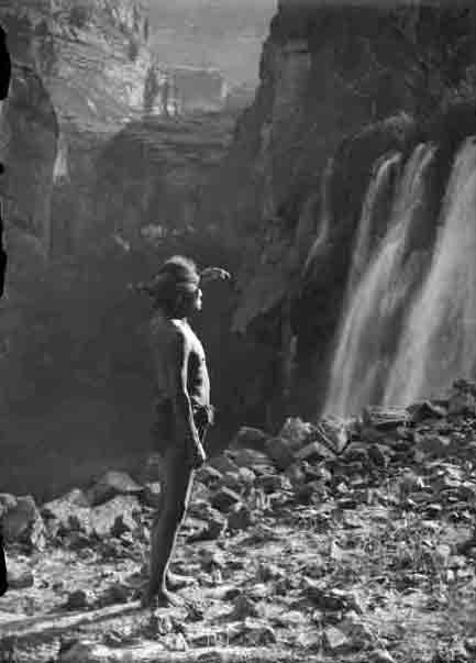
Thilwisa, a Havasupai known to Euro-Americans as “Captain Burro,” befriended William Wallace Bass and showed him many parts of the Grand Canyon. Photo taken at Bridal Veil Falls, today known as Havasu Falls, on the Havasupai Reservation sometime between 1907-1913.
Photo: NAU.PH.568.6289 Kolb Bros. Collection. Cline Library, Northern Arizona University.
Although questions concerning American Indian reservation boundaries, private land inholdings, and extractive commercial uses inside Grand Canyon National Park were mostly settled in the twentieth century, twenty-first century issues concerning the proper use of America’s public domain grow ever more complex. At the national level, the Park Service and organizations concerned with the park’s environmental welfare argue against commercial development on adjacent lands that can potentially harm park values, such as uranium mining on national forest land at Red Butte and along the canyon’s North Rim.
American Indian tribes generally support environmental protection efforts while continuing to argue for enlarged reservations and/or greater opportunities for tribal members to engage in traditional as well as modern economic uses of lands and resources within and beside the park. Tensions of lesser or greater degree play out between special interests and land managers over hiking and river running permit systems, concessions, and the manner in which ordinary visitors to the North and South Rims enter and move about the park. In other words, Grand Canyon residents and international visitors still “treat the earth and each other with a frank, energetic self-assertiveness,” as Worster posited, but moral and aesthetic sentiments as well as special interest politics influence decisions concerning use of the national parks and the broader public domain lands.
Next time you consider the canyon’s history, its American Indian residents, explorers, pioneers, rangers, tourism operators, and visitors, think about how much the land and historical characters’ perceptions and uses of the land have influenced past events and led to today’s park policies.
Written By Michael Anderson and Paul Hirt
References:
- Anderson, Michael F. Living at the Edge: Explorers, Exploiters and Settlers of the Grand Canyon Region. Grand Canyon Association, 1998.
- Anderson, Michael F. Polishing the Jewel: An Administrative History of Grand Canyon National Park. Grand Canyon Association, 2000.
- Billingsley, George H., Earle E. Spamer, and Dove Menkes. Quest for the Pillar of Gold: The Mines and Miners of the Grand Canyon. Grand Canyon Association, 1997.
- Morehouse, Barbara J. A Place Called Grand Canyon: Contested Geographies. University of Arizona Press, 1996.